Showing posts with label Axios. Show all posts

Friday, September 7, 2012

uDig Welcomes back Axios Spatial Editing Tools

The much loved Axios Spatial Editing Tools are back! These tools are included in latest uDig 1.3.2 release and do not require a separate download.


Thanks to the supportive community I was able to apply for Google Summer of Code 2012 and succeeded in porting the Spatial Tools available to the latest uDig. This success is due to the large commitment of Anne Ghisla (OSGeo SoC Administrator), Mauricio Pazos and Andrea Antonello (my two mentors) and Jody Garnett (teacher of a wonderful kick-off course). Thank you!

The project outcome is available to all of you in the uDig 1.3.2 release.

The Spatial Editing Tools provide facilities to perform key geometry editing tasks:
  • Split
  • Merge
  • Create Arc
  • Create Parallel
  • Trim
These tools behave as they did in uDig 1.2 but ...

Merge

In addition to the Merge Tool, there is now a new Merge Operation!

A new work flow has been created: now it is possible to select features using Box Selection Tool (or Table view), right-click on them and fire a "Operations --> Merge Selected" action.
This allows feature selection to be controlled directly in the Map window, relying on the selection refinement capabilities of the Box Selection Tool (Ctrl+Click to remove, Shift+Click to add).

In shorts, Merge Tool usage should be now much more 'user-friendly'!


A sequence through the new Merge Tool "Operation" work flow.

Spatial Tools

To follow a set of sequences showing the spatial tools in action.
Using the Arc Tool.
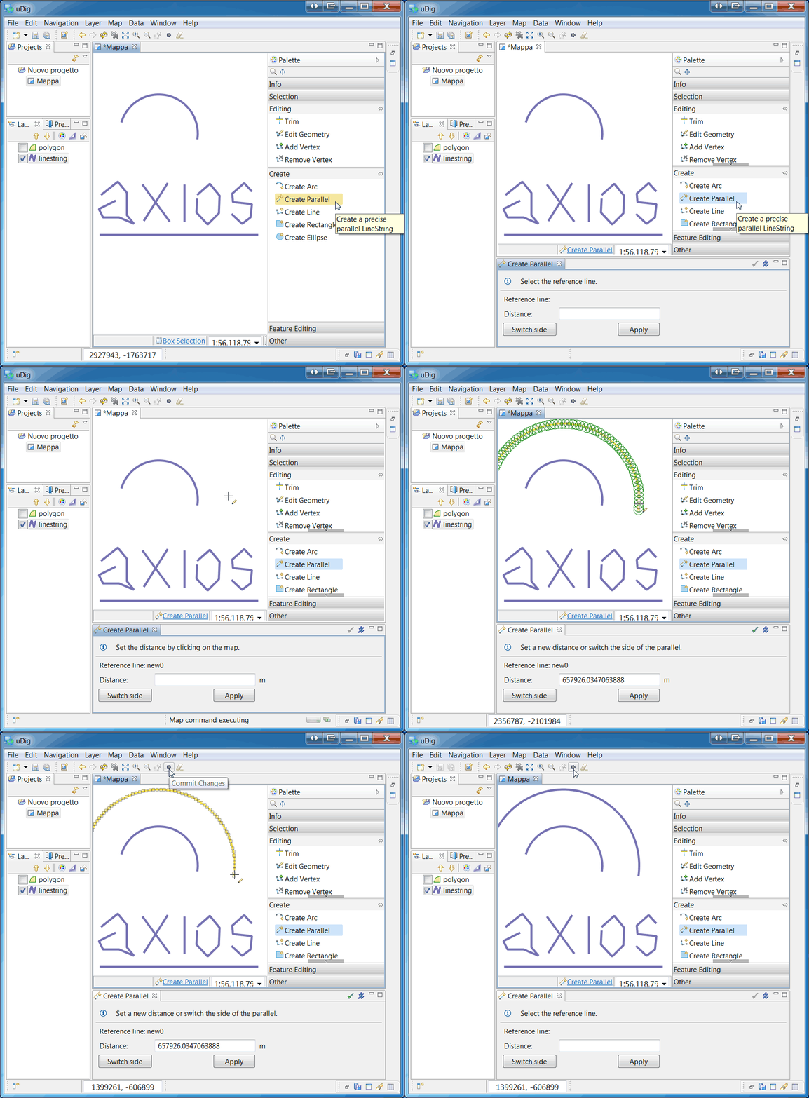
Using the Parallel Tool.
Using the Trim Tool.
Using the Split Tool.


More information will be soon available in the User Documentation (stay tuned!)

Thursday, April 26, 2012

uDig in GSoc 2012


Same as in the past years uDig it partecipating in the Google Summer of Code 2012.

This year two students proposed projects to our community:

Carol Hansen, which will enable uDig users to plot shortest-path route of OSM data, using a Neo4j-Spatial API. She will be mentored by a last year's students of our community, Davide Savazzi, and supported both by Neo4j's and our community.

The second project is by Marco Foi, an Italian Geologist, which will bring back what the latest releases of uDig are heavily missing: the Axios toolset. As his project states, he will be porting the Axios Spatial Tools into uDig core 1.3. Marco will be mentored by our vector tools expert Mauricio Pazos.

We all do welcome Carol and Marco into our community and hope they will enjoy the projects they are starting to work on.

Big kudos go to the Osgeo coordinators and the Summer of Code project for their support and patience during the less technical parts of the project kick-off.

Tuesday, June 21, 2011

Running the Image Georeferencing View. Release 1.0.0 for uDig 1.2.1

We have released the Image Georeferencing View, versión 1.0.0. It was tested with uDig 1.2.1. The following video shows a typical session.

In this video the user adds the ground control points (GCP) using a road layer as base.


The following video shows as a georeferenced raster can be used to draw a new road layer (vector layer) .
To georeference the raster, the user provides the set of ground control points graved by a GPS device.


Thursday, May 19, 2011

Image Georeferencing View RC3 for uDig 1.2.1


We have released the Image Georeferencing View RC-3. It includes some new user interface features that show the relations between image's marks and the set of gound control points. New tools have been inlcuded in order to manipulate the image and the ground control points.


Finally, the Help (draft) is available too.

To know more about this project, please, go to Axios Community Space.

Wednesday, May 4, 2011

Image Georeferencing View for uDig 1.2.1

A month ago, we began the development of Image Georeferencing. Now we want to share the first release in order to test it.


Right now, we are working in some improvements in the usability (zoom, pan, fit, etc). More details and download instructions in the Axios Community Wiki

Comments are welcome

Friday, March 11, 2011

Spatial Operations Tutorials for Udig 1.2.1

Hello everyone, recently, we have improved the Spatial Operation Framework in order to do easy its extension with some new operations. Thus, we have updated the following tutorials:
  • How to add a New Spatial Operation

  • Reusing Existent Spatial Process. Integrating Sextante


Important, this new feature is compatible with uDig 1.2.1.

To download, visit the section Tutorials and Documents in www.axios.es

Tuesday, March 8, 2011

Spatial Operations & Editing Tools for uDig 1.2.1

We have published a new release of our Spatial Operations & Editing Tools for uDig 1.2.1 project.
It includes many fixed bugs and performance improvements.
Now, the product is provided as:
  • Editing Tools 1.3.3 for uDig 1.2.1
  • Spatial Operations 1.3.1 for uDig 1.2.1
This features are available in uDig Community Updates Site:
http://udig.refractions.net/update/1.2/community

To download the source and binary distributions, visit our download page in www.axios.es.

Wednesday, December 1, 2010

Axios uDig extensions - Releases 1.3.2 and 1.2.9

We have published the 1.3.2 version for uDig 1.2. This release fixes those bugs present in the last version. Additionally, we have done the backporting to 1.2.9, compatible with uDig 1.1.

These releases are available in uDig Community Updates Site:
http://udig.refractions.net/update/1.2/community
http://udig.refractions.net/update/1.1/community

To download the source and binary distributions, visit our download page in www.axios.es.

Finally, we want to highlight the excellent testing work done by the Municipal Department of Automated Data Processing, Information and Communications Technologies, Vienna City. The have been working hard producing 685 test scenarios for the split tool.

Thursday, October 7, 2010

Axios uDig Extensions release 1.3.1 for uDig 1.2.x

We have published a new release of Axios uDig Extentsions. This version includes fixes and improvements for the Split Tool.

A closed split line can be drown as shown in the screenshot.

The result of split transaction produces:

The split operation is available as a Spatial Operation too. Thus it is possible to split the feature in a layer using lines present in another layer.

This release is available in uDig 1.2 - Community Updates Site:
http://udig.refractions.net/update/1.2/community

To download the source and binary distribution, visit our download page in www.axios.es


Thursday, July 15, 2010

Axios uDig Extensions releases 1.2.5 for uDig 1.1 and 1.3.0-m6 for uDig 1.2

We have published a new releases of Axios uDig Extentsions. The 1.3.0-m6 version for uDig 1.2 includes many fixes for the Split Tool.

Additionaly, we have done the backporting to 1.2.5, compatible with uDig 1.1.

Theses release are available in uDig Community Updates Site:
http://udig.refractions.net/update/1.2/community
http://udig.refractions.net/update/1.1/community

To download the source and binary distribution, visit our download page in www.axios.es

Monday, May 10, 2010

Reusing Existent Spatial Operations

Recently, we have published a tutorial which could be interesting for those developers who want to integrate existent proceses in uDig framework.

This tutorial uses the Spatial Operation Framework, developed under the auspices of Gipuzkoa Provincial Council, Mobility and Land Planning Department, and Sextante, promoted by Spanish autonomous region of Extremadura.

As platform we use uDig 1.2 and Spatial Operations 1.3.

To download, visit our web site www.axios.es and select Tutorials and Documents.

Thursday, February 11, 2010

Axios uDig Extensions release 1.2.4 for uDig 1.1

A new Axios uDig Extensions bug fix release is available in the udig update site.

It includes many fixes in the parallel tool.

cheers

Monday, December 21, 2009

Axios uDig Extensions 1.2.3 for uDig 1.1

Recently, we have published the release 1.2.3. It includes fixes for the Split and Parallel tools and cap styles for the Buffer spatial operations.

This product is available in the udig update site and www.axios.es download page.


Thursday, November 12, 2009

How to add a new spatial operation

Hello everyone, we have published a tutorial which shows how to extend the spatial operations framework with new spatial operations.

We expect this document to be interesting for those developers who want to include existent spatial operations or develop a new spatial operation for uDig, taking advantage of the spatial operations framework.

In this tutorial we develop the spatial operation Centroid. The screenshot shows the user interface idea. In the presented example the centroid operation has created a new layer called Centroid_1 using as source layer the countries layer.

To download visit our web site www.axios.es, "Tutorials and Documents".

cheers

Friday, November 6, 2009

AXIOS UDIG EXTENSIONS 1.2.2

This release, available for uDig 1.1.x, includes improvements
and bug fixes in the Parallel Tool.

Also, you could have a look in the development branch. The axios suit 1.3.0-m2 was tested with uDig 1.2 M6.

To download this new releases please visit the uDig update-site or our web site www.axios.es download page.

Friday, August 14, 2009

AXIOS UDIG EXTENSIONS 1.2.0

This release, available for uDig 1.1.x, includes new features, improvements and bug fixes. We want to highlight the following ones:


NEW FEATURES

  • Spatial Operation Split splits features from a source layer using a LineString features from a second layer (or reference layer).
  • Spatial Operation Fill creates a new geometry using the reference line and the border of the source polygon as its own border.
IMPROVEMENTS

  • Merge Tool the usability has been improved in several ways.

  • New Split algorithm, it allows add vertex to neighbour geometries. Additionally, it solves many reported problems in the old split tool.

  • Spatial Operation Dissolve allows to select multiple dissolve property.

  • The spatial operation framework was factored to provide an easy way to extend with new operations. Thus the control logic was encapsuled in abstract classes to simplify the creation, associations presenters- commands and event handling .
  • Spatial Operation Extensions Point allows to add new spatial operations in the default set.

To download this new release please visit the uDig update-site or our web site www.axios.es download page.

Finally, we want to thank uDig community for your comments and suggestions to improve this product.


If you want to know more about this project visit the
following page: uDig Axios Community Space - Spatial Operations and Editing Tools

Monday, June 15, 2009

AXIOS UDIG EXTENSIONS 1.2.0-RC01 (Testing)

This release, available for uDig 1.1.x, includes new improvements and bug fixes. We want to highlight the following:

Split Operation. We have fixed the split behaviour to split a geometry properly using complex split line like it's shown in the following figures.


Split Operation. Fixed the split behaviour to split geometries properly when splitting several neighbour features.

– The Spatial Operations framework was refactored to provide an extension point that could be used by other developers to add new operations.

To test this new release please visit the uDig update-site or our web site www.axios.es download page. Here you can find the latest stable release Axios uDig Extensions 1.1.4, as well as the latest under development release Axios uDig Extensions 1.2.0-RC01 for uDig 1.1.x.

If you want to know more about this project visit the
following page: Spatial Operations and Editing Tools

Tuesday, March 24, 2009

AXIOS UDIG EXTENSIONS 1.1.2

This release, available for uDig 1.1.1, includes new improvements and bug fixes. We want to highlight the following main improvement:

Split Operation. We have improved the split behavior by allowing the tool to add one or more vertexes to the neighbor geometries (whose boundaries are intersected by the split line) of the one that has been split.

To test this new release please visit the uDig update-site or our web site www.axios.es download page. Here you can find the latest stable release Axios uDig Extensions 1.1.2, as well as the latest under development release Axios uDig Extensions 1.2-M3 for uDig 1.1.1.

If you want to know more about this project visit the following page: Spatial Operations and Editing Tools

We want to thank Rudolf Hochmeister from the Municipal Department of Automated Data Processing, Information and Communications Technologies, Vienna City, for his contribution to improve this project.

Friday, February 13, 2009

AXIOS UDIG EXTENSIONS 1.2-M2 (UNDER DEVELOPMENT)

This release, available for uDig 1.1.1, include the following new operations:
- Fill Spatial Operation. It creates new geometries
using the reference lines, present in other layer, and the borders of the source polygons as their own borders.

- Hole Spatial Operation. It makes holes inside a polygon feature using valid LineStrings that are present in another layer, used as reference.


To test this new release please visit our web site www.axios.es download page. Here you can found the latest stable release Axios uDig Extensions 1.1.1 for uDig 1.1.1.

If you want to know more about this project visit the
following page: Spatial Operations and Editing Tools

Wednesday, January 21, 2009

Axios uDig Extensions 1.2-m1 (under Development)

We want to share with the community these new features under development, added to spatial operation set:
  • Split operation: allows to split layer's features using lines from other layer.


  • Polygon to line operation: taking the polygons' borders as reference, generates new features with line string geometries.

This release is intended for users who want to test this new features. Please, protect your data before use this product.

You will find download instructions and help in Axios Download

If you want to know more about this project visit the
following page: Spatial Operations and Editing Tools