Showing posts with label tool. Show all posts

Friday, September 7, 2012

uDig Welcomes back Axios Spatial Editing Tools

The much loved Axios Spatial Editing Tools are back! These tools are included in latest uDig 1.3.2 release and do not require a separate download.


Thanks to the supportive community I was able to apply for Google Summer of Code 2012 and succeeded in porting the Spatial Tools available to the latest uDig. This success is due to the large commitment of Anne Ghisla (OSGeo SoC Administrator), Mauricio Pazos and Andrea Antonello (my two mentors) and Jody Garnett (teacher of a wonderful kick-off course). Thank you!

The project outcome is available to all of you in the uDig 1.3.2 release.

The Spatial Editing Tools provide facilities to perform key geometry editing tasks:
  • Split
  • Merge
  • Create Arc
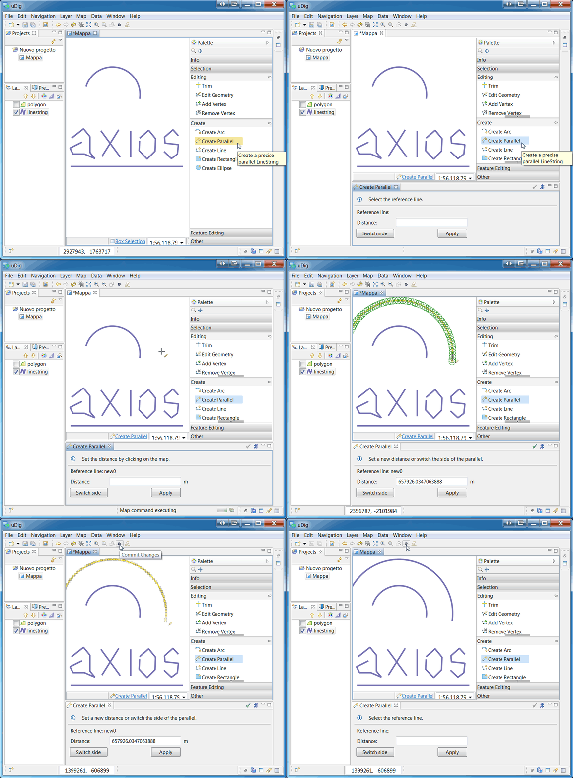
  • Create Parallel
  • Trim
These tools behave as they did in uDig 1.2 but ...

Merge

In addition to the Merge Tool, there is now a new Merge Operation!

A new work flow has been created: now it is possible to select features using Box Selection Tool (or Table view), right-click on them and fire a "Operations --> Merge Selected" action.
This allows feature selection to be controlled directly in the Map window, relying on the selection refinement capabilities of the Box Selection Tool (Ctrl+Click to remove, Shift+Click to add).

In shorts, Merge Tool usage should be now much more 'user-friendly'!


A sequence through the new Merge Tool "Operation" work flow.

Spatial Tools

To follow a set of sequences showing the spatial tools in action.
Using the Arc Tool.
Using the Parallel Tool.
Using the Trim Tool.
Using the Split Tool.


More information will be soon available in the User Documentation (stay tuned!)

Monday, October 3, 2011

Tool Palette and Options

Tools have gotten a major usability improvement featuring:

  • ToolPalette - used to quickly explore available tools, configure tool display to show labels, descriptions or large icons for a helpful hand when learning. By default the Palette is displayed along side your Map; you can also Choose Show View > Other and Open the Palette on its own as a tear off View. This is great for users with more than one monitor or when you have multiple maps open side by side. This is the same Palette used during Page printing.
  • ToolOptions - quick access to common tool preferences from the Map Status Line. This has allowed us to reduce the number of tools while maintaining the same functionality.

These change combine to make uDig even more User-friendly with a presentation of tools similar to a paint program. As an example edit tools can use the area to make options such as "snapping" visible (previously available as a keyboard shortcut!). It is also an efficient use of screen real estate as snapping options do not waste space when they are not needed.

Palette

Here are a couple examples how how the palette looks using the Large Icons preference.

Extension

uDig practices an open development model with a couple Request for Change proposals being closed today.

As part of that the following pages have been updated in the user guide:

For more information about what is new in the uDig 1.2 series see the user guide.

And developer documentation for the new tool option functionality:

The good bit is covered here:
public class OptionContribtionItem extends ToolOptionContributionItem {
     public IPreferenceStore fillFields( Composite parent ) {
            Button check = new Button(parent,  SWT.CHECK );
            check.setText("Scale");
            addField( NavigationToolPreferencePage.SCALE, check );
         
            Button tiled = new Button(parent,  SWT.CHECK );
            tiled.setText("Tiled");
            addField( NavigationToolPreferencePage.TILED, tiled );
            
            return ToolsPlugin.getDefault().getPreferenceStore();
        }
    };

Wednesday, December 1, 2010

Axios uDig extensions - Releases 1.3.2 and 1.2.9

We have published the 1.3.2 version for uDig 1.2. This release fixes those bugs present in the last version. Additionally, we have done the backporting to 1.2.9, compatible with uDig 1.1.

These releases are available in uDig Community Updates Site:
http://udig.refractions.net/update/1.2/community
http://udig.refractions.net/update/1.1/community

To download the source and binary distributions, visit our download page in www.axios.es.

Finally, we want to highlight the excellent testing work done by the Municipal Department of Automated Data Processing, Information and Communications Technologies, Vienna City. The have been working hard producing 685 test scenarios for the split tool.

Thursday, July 15, 2010

Axios uDig Extensions releases 1.2.5 for uDig 1.1 and 1.3.0-m6 for uDig 1.2

We have published a new releases of Axios uDig Extentsions. The 1.3.0-m6 version for uDig 1.2 includes many fixes for the Split Tool.

Additionaly, we have done the backporting to 1.2.5, compatible with uDig 1.1.

Theses release are available in uDig Community Updates Site:
http://udig.refractions.net/update/1.2/community
http://udig.refractions.net/update/1.1/community

To download the source and binary distribution, visit our download page in www.axios.es

Sunday, August 31, 2008

Geosolutions coverage tools in Udig / JGrass

Today I ported the Geosolutions coverage tools into Udig, but throught the JGrass side. That has several reasons, which I explain at the complete report link.