Showing posts with label gsoc. Show all posts

Friday, September 7, 2012

uDig Welcomes back Axios Spatial Editing Tools

The much loved Axios Spatial Editing Tools are back! These tools are included in latest uDig 1.3.2 release and do not require a separate download.


Thanks to the supportive community I was able to apply for Google Summer of Code 2012 and succeeded in porting the Spatial Tools available to the latest uDig. This success is due to the large commitment of Anne Ghisla (OSGeo SoC Administrator), Mauricio Pazos and Andrea Antonello (my two mentors) and Jody Garnett (teacher of a wonderful kick-off course). Thank you!

The project outcome is available to all of you in the uDig 1.3.2 release.

The Spatial Editing Tools provide facilities to perform key geometry editing tasks:
  • Split
  • Merge
  • Create Arc
  • Create Parallel
  • Trim
These tools behave as they did in uDig 1.2 but ...

Merge

In addition to the Merge Tool, there is now a new Merge Operation!

A new work flow has been created: now it is possible to select features using Box Selection Tool (or Table view), right-click on them and fire a "Operations --> Merge Selected" action.
This allows feature selection to be controlled directly in the Map window, relying on the selection refinement capabilities of the Box Selection Tool (Ctrl+Click to remove, Shift+Click to add).

In shorts, Merge Tool usage should be now much more 'user-friendly'!


A sequence through the new Merge Tool "Operation" work flow.

Spatial Tools

To follow a set of sequences showing the spatial tools in action.
Using the Arc Tool.
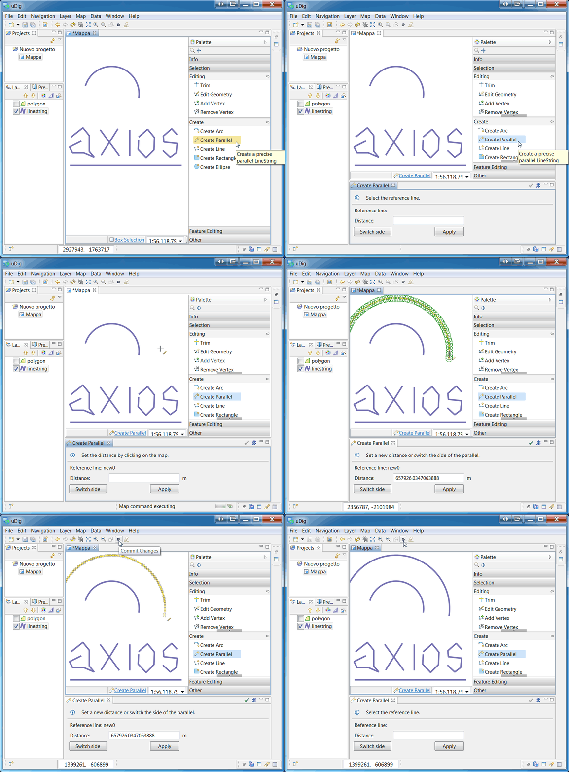
Using the Parallel Tool.
Using the Trim Tool.
Using the Split Tool.


More information will be soon available in the User Documentation (stay tuned!)

Thursday, April 26, 2012

uDig in GSoc 2012


Same as in the past years uDig it partecipating in the Google Summer of Code 2012.

This year two students proposed projects to our community:

Carol Hansen, which will enable uDig users to plot shortest-path route of OSM data, using a Neo4j-Spatial API. She will be mentored by a last year's students of our community, Davide Savazzi, and supported both by Neo4j's and our community.

The second project is by Marco Foi, an Italian Geologist, which will bring back what the latest releases of uDig are heavily missing: the Axios toolset. As his project states, he will be porting the Axios Spatial Tools into uDig core 1.3. Marco will be mentored by our vector tools expert Mauricio Pazos.

We all do welcome Carol and Marco into our community and hope they will enjoy the projects they are starting to work on.

Big kudos go to the Osgeo coordinators and the Summer of Code project for their support and patience during the less technical parts of the project kick-off.

Saturday, May 8, 2010

Google Summer of Code 2010

In two weeks time the Google Summer of Code for 2010 starts, and this year uDig is taking part with an exciting project riding the current NoSQL wave, one of the hottest topics concerning databases in a long time.
Davide Savazzi, a student at the Università degli Studi di Pavia, Italy, and an experienced GIS developer, is doing a project titled 'Adding support for Neo4j graph database in Geotools and uDIG'. We are particularly excited to have Davide involved in this project because he has already made core contributions to the underlying 'Neo4j Spatial' project, which is building GIS capabilities into the graph database itself.

Introduction

Geographic vector data is naturally structured like a graph, network and topological analyses view GIS data as graphs, but so far no-one has tried to make use of a real graph database as the backing store for a GIS.

Neo4j is a new open source database that stores data as a graph, in the mathematical sense of nodes connected by relationships, with both nodes and relationships storing properties as key-value pairs.

The goals of the project are:
  • extend Neo4j graph database with spatial indexing and query functions.
  • enable GIS application developers working on either or both Geotools and uDIG to use Neo4j as a true spatial database.
  • enable GIS users working with uDIG to perform spatial analyses better or faster than normal.

Roadmap

At the highest level, the project will take the following phases:
  • define the best approach to store spatial data in Neo4j graph database
  • create spatial indexing and query functions for Neo4j
  • create a Geotools DataStore that can read and write spatial data contained in Neo4j
  • add a Catalog to uDIG for this new DataStore
  • add persistence support to Geotools graph module through Neo4j
  • prototype a plugin in uDIG for network / routing analyses

Further reading

Here are a few links worth investigating, for those of you interested in some background on this subject:Once the project starts we will post status updates and further information.